


bec hellouin

thle
User
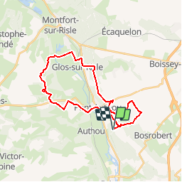

Length
26 km

Max alt
166 m

Uphill gradient
457 m
Km-Effort
32 km

Min alt
32 m

Downhill gradient
455 m
Boucle
Yes
Creation date :
2016-01-08 00:00:00.0
Updated on :
2016-01-08 00:00:00.0
3h59
Difficulty : Easy

FREE GPS app for hiking
 SityTrail
IGN / Geographical institutes
SityTrail Plus
The world is yours!
About
Trail Equestrian of 26 km to be discovered at Normandy, Eure, Le Bec-Hellouin. This trail is proposed by thle.
Positioning
Country:
France
Region :
Normandy
Department/Province :
Eure
Municipality :
Le Bec-Hellouin
Location:
Unknown
Start:(Dec)
Start:(UTM)
333681 ; 5455442 (31U) N.
Comments